Jinung Beigabup campsite to Boonar Mundak campsite.
We had a good night's rest awakening early with the song of kookaburras. Just
as well as we have a long day ahead with over 70km to cover. It doesn't sound
much, on a road bike I'd cover 70km in 2 to 3 hours. On a mountain bike
laden with panniers your speed is cut down to an average 10 to 15 kph
depending on what the road surface and gradients are like.

- Distance covered today = 56km. Temperatures 16 to 26 °C and hotter inland. No rain, hardly any wind.

The track out of the hut was not as steep as the way in, the track
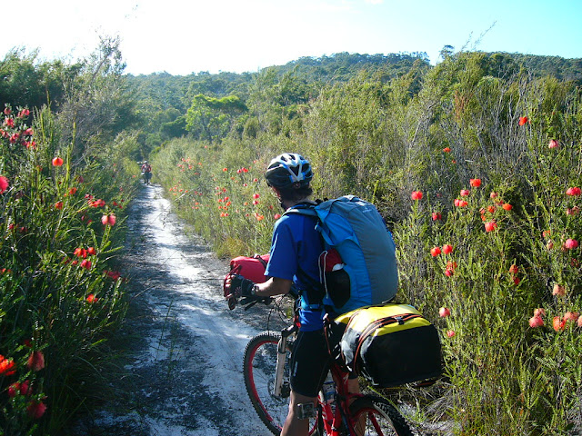
started out as a pleasant forest track with a few sticks that found their way
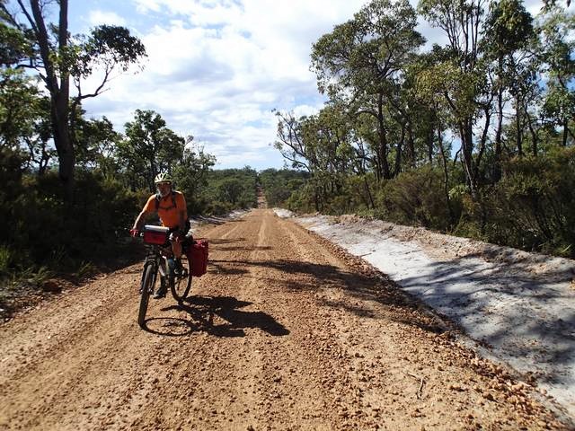
into the wheels occasionally. Then it transitioned to dirt road. Today
we had heat and pea gravel on the roads. The pea gravel is like marbles,
making the ride quite treacherous especially if the road is steep. The with
the increasing heat and humidity the march flies were making the most of the
last days of March to go on full scale attack whenever we stopped.

On a steep downhill pea gravel coated road we met a couple of ladies in
their late 60s heading in the opposite direction having travelled from Perth.
I had difficulty stopping, but Ed and Jon were able to and had a good yarn and
rendered some assistance to rectify a squeaking noise. It turns out these
ladies had something in common with Jon having travelled to the tip of the
'Cape'. I also found out later that these ladies discovered a dead
person just outside Perth. It was printed in the news that this fellow had a
car accident, then was killed by a hit-run after trying to flag someone to
give him help. They had to spend hours talking to police filling in reports.
This ride started out well, but became a bit of a chore with its long sections of gravel topped dirt road. IT was hard to enjoy the rolling hills due to the gravel surface. We became separated a bit due to the different speeds of the bikes and rider nervousness. The 29ers (mine and Ed's) roll very well and seem to deal better with soft sand.
The whole part of the ride wasn't that bad. There was some reprieve as a nice swimming spot was found at around lunch on the Kent River. I missed the little side route, but fortunately the others did not and Jon came and invited me round as I waited at the road crossing. However, the road crossing offered some shade and nice cut logs to lunch on so we got the best of both worlds.

If the pea gravel road made life a bit precarious, the soft sand made life
difficult. Just before camp we had some work to do. Jon with his loaded
front panniers and skinny marathon Schwalbe tyres was having a lot of
difficulty in spots.
Mark last night made a fateful remark. We were commenting on the pros and cons of panniers versus backpacks. One of the remarks was about the additional stability that panniers offer (though not on the front in the soft or slippery stuff). Mark boldly stated that he hadn't fallen off yet. Things changed with him covered in dirt and sand on a speedy descent to the ground on the soft sand. I used to do all of my mountain bike touring with backpacks, but suffered with back pain and numbness on the hands. A properly balanced and secured rack is the way to go.
Mark last night made a fateful remark. We were commenting on the pros and cons of panniers versus backpacks. One of the remarks was about the additional stability that panniers offer (though not on the front in the soft or slippery stuff). Mark boldly stated that he hadn't fallen off yet. Things changed with him covered in dirt and sand on a speedy descent to the ground on the soft sand. I used to do all of my mountain bike touring with backpacks, but suffered with back pain and numbness on the hands. A properly balanced and secured rack is the way to go.

Tyre choice proved to be a major factor on this ride. I was very happy
with my set up, the bike handled very well. The tyres were perfectly suited to
this terrain (Maxxis UST tubeless Crossmark). The dual suspension just soaked
up the bumps, and corrugations. I learnt how well the suspension handled the
corrugations when I accidentally locked out the rear suspension. My back
suffered a bit after making that mistake.

The campsite was as good as the other one. The department of corrective
services assisted in the construction of these huts and they did an excellent
job. These huts should last a good many years. Again the water was good and
the hut / toilet clean. We made sure to sweep up before and after leaving to
give the same experience to the next guests.

Tonight we again cooked our various gourmet meals. Ed and I, Mark and Nev,
Jon; each team cooked up a splendid meal and we polished off the remaining
cheese, chocolate for dessert. Ours was vegetarian tonight with couscous and
stir fried vegetables and olives. Nev made a nice spice mix for the
couscous which added well to the flavour. Lunch isn't too bad either with
tinned sardines or salmon, carrot, tomato, capsicum and cucumber on
mediterranean flavoured flat bread. When you are camping, you need to eat
well.
We had a bit of a pow wow tonight. There was concern that we were becoming too strung apart. This, unfortunately is easy to do on these long rolling hills and differences in bikes, skill and fitness levels. I felt today it was a case of go to a marker or junction and wait for the group to rejoin. I was glad to get the gripes out in the air though as tensions such as these build like festering sores. It is a bit harder also, because we never got to work as a group until the ride start, and I never met Mark nor Jon. So tomorrow we do not leave too wide a gap and see how we go.
Off to bed early again tonight. It was a hot day and a big one. We are tired.
The maps and other blogs give us good clues, as well as the spacing of the campsites. You can get a lot out of the map by carefully examining it. The trail is marked in solid blue with yellow dots, solid red lines are roads, long dashed red lines are dirt roads, thinner ones single lane trails, and small dashes are tracks. The Munda Biddi track is superimposed on these road/track marks. Some improvement can be made on the maps by making the Munda Biddi trail marker translucent so you can readily identify the trail type rather than making a guestimate. Also whole sections of the map are wasted with information that could be better placed on the cover leaf - detail such as 'be careful' notes are better placed as an information insert leaflet. It is important to have as much as the map present so that informed decisions can be made about escape routes should an early exit be required.

The maps also have a terrain profile with a cycling guide with rating scale
Easy, Intermediate or Difficult. One has to be careful with these ratings as
the surface: sand, pea gravel or sticks can make the going very hard and the
weather - rain or heat can dramatically alter the experience.

Contents
Navigate- Previous: Denmark to Jinung Beigabup campsite
- Next: Boonar to Walpole
Comments
Post a Comment